CHAPTER 19
DOES A MAP CHANGE YOUR MIND?
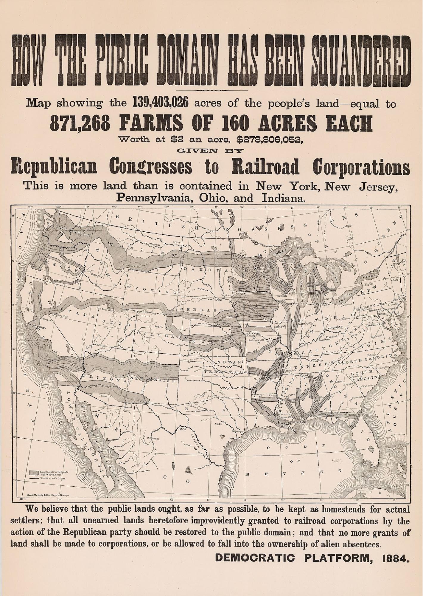
Figure 19.1. How the Public Domain Has Been Squandered, 1884. Published by the Democratic Party. This campaign map uses geography as an argument, not merely as a locator, showing how mapped framing can be designed to persuade. Cornell University Library, Persuasive Cartography: The PJ Mode Collection, 1088.01. Public domain.
A student sits down with a page of questions and is asked to estimate the size of the world from memory.
Suppose Greenland is 1,000 units. How large is Canada? Russia? India? New Zealand? The student is not being asked for exact square kilometres. The researchers want something more interesting: the shape of the world that remains after the map is gone.
Then the task changes. Imagine standing in California and pointing toward a distant city by the shortest route across the surface of the Earth. Tokyo. Moscow. Cape Town. Which direction would you point?
These were the kinds of questions used by geographer Daniel Montello and cartographer Sarah Battersby in a long-running attempt to test one of the most persuasive claims in projection politics: does repeated exposure to the Mercator map distort the world in our heads?
The claim is easy to believe because Mercator enlarges high latitudes dramatically. Greenland looks enormous, Russia and Canada expand, and Africa looks comparatively smaller. If people see this picture often enough, perhaps they store its proportions and later reproduce them without the map present.
The first half of that argument is mathematics; the second is psychology. The psychological result cannot be read off the projection equations.
Battersby and Montello tested the area question directly in 2009.[1] Participants estimated the relative areas of world regions from memory. If a strong Mercator effect existed, places at high latitudes should have been systematically overestimated in something like the pattern produced by the projection.
That was not the pattern they found. People were imperfect at estimating area, as people generally are when asked to compare large magnitudes from memory, and small regions tended to be overestimated relative to large ones. But participants’ estimates related more closely to actual geographic area than to Mercator’s latitude-driven enlargement. A person can therefore be wrong about geography without being wrong in the particular way Mercator predicts.
Perhaps the study had caught the wrong generation. Those participants had grown up with printed atlases and a mixture of projections. What about younger people immersed in digital mapping and years of Web Mercator?
Researchers tested that possibility too. A 2019 study of young people in Belgium and the United States looked for a Mercator-like imprint in estimates of countries and continents.[2] Again, the expected projection signature was difficult to find. Education and individual knowledge appeared more important than simple exposure to one projection.
Then the sample became enormous. A worldwide study published in 2020 gathered more than 130,000 responses.[3] If a strong global Mercator effect on remembered area were common, this was a good place to see it.
The results again resisted the slogan. Participants did not reproduce the systematic latitude-driven area pattern that a simple Mercator-memory theory predicted. Europe was often overestimated, but the broader pattern followed other human judgement effects more strongly, including the tendency to overestimate small regions and underestimate very large ones.[4] In some comparisons, Mercator did not even produce worse estimates than Gall-Peters.
Mercator remains a poor map for comparing global area, and Greenland remains visually too large on it. The experiments show that an objectively distorted display does not necessarily leave the exact long-term memory effect critics expect.
Mathematical distortion, immediate perception and later memory are different questions. A viewer can see Greenland enlarged while the map is present and may misunderstand its size at that moment, yet later draw on other knowledge such as numbers learned at school, globes, other projections, travel, news, geographic facts and reasoning. The mind is not a screenshot folder or a single internally consistent miniature atlas.
That became even clearer when researchers turned from area to direction. In 2022, Montello and Battersby again found little evidence for the expected Mercator effect on remembered areas, but they asked participants another question: from a given place, in what direction lies a distant city along the shortest route over the globe?
A rectangular world map becomes deceptive here in a different way. Great-circle routes can begin in directions that look surprising on a flat map, because the shortest route on a sphere does not behave like a straight line drawn across a familiar rectangle. Participants were explicitly told to think about the shortest route over Earth’s surface, the way a jet might fly, yet their answers often followed the flat-map intuition. Where the correct spherical direction and the Mercator-like planar direction differed substantially, average estimates were far closer to the planar answer than to the spherical one.
The directional result was consistent with an effect from Mercator or familiar rectangular mapping, but not with the famous remembered-area claim.[5] Instead of asking whether a projection enters the mind, the better question is which properties enter which kinds of judgement.


A person may know that Africa is much larger than Greenland and still imagine the direction to Europe as though the world were a flat rectangle. They may know New Zealand is far from Britain and still draw the Pacific badly from memory. They may understand that Mercator distorts area and still be unable to mentally correct the distortion region by region.
Cognitive geography is fragmented. Montello and Battersby suggest something more like a cognitive atlas than a single mental map: remembered facts, directions, routes, images and relationships learned from different sources and not necessarily geometrically consistent with one another.
That idea fits ordinary experience. Most people can navigate their neighbourhood without knowing its exact area. They can know two countries are neighbours without knowing their relative size. They can understand that Japan lies north of New Zealand and still fail to draw the coastlines accurately.
The knowledge is useful without being one perfect picture, and projection literacy does not automatically solve the problem. Research has found that people may know in general that world projections distort while struggling to apply that knowledge to a specific judgement.[6] Novices often use familiar continental shapes as clues to whether a projection looks trustworthy, while more experienced readers may use the graticule and other systematic cues.
That creates a practical problem for reform. An equal-area projection can be mathematically better for comparing territory and still look wrong to someone who has learned that familiar shapes are evidence of accuracy. Gall-Peters is the obvious example: its stretched equatorial forms preserve area exactly, yet many viewers read the unfamiliar shapes as distortion without understanding which property has been protected. Changing the map therefore works better when the reader is also told what changed.
The story becomes more political when maps are combined with words because people rarely encounter maps in isolation. A news map arrives with a headline, a school map with a lesson, a military map with a briefing and a social-media map with a caption. The projection is one cue among labels, colours, framing and prior beliefs.
A 2024 experiment tested exactly this interaction. Participants considered a hypothetical United States purchase of Greenland while viewing different projections and different verbal frames, including economic and national-security framing.
The projection did not produce one uniform response. Under the national-security frame, however, the Mercator view changed some judgements relative to Gall-Peters, including perceived importance associated with Russia, which then related to attitudes toward the hypothetical purchase. Under the economic framing, the same pattern did not appear in the same way. That conditional result is a more plausible model of how political maps can influence people than any claim of a universal projection effect.
Maps are not hypnotic devices. They are part of an information environment in which a large-looking Russia may become more salient when the accompanying words already tell the viewer to think about military threat. Under another framing, the same visual size may matter less. The picture and the argument can reinforce each other.
The result supports a smaller, testable claim: projection can interact with framing to influence judgement under some conditions.[7] It does not establish a general causal account of real-world policy.
Smaller claims are useful because they can survive evidence. A 2024 review of research on cognition and map projections reached a similarly cautious conclusion: the evidence base is real but thinner and more uneven than public claims often imply.[8] Samples are frequently narrow, projection properties are sometimes misunderstood, and studies test different psychological outcomes that cannot simply be merged into one assertion that maps shape worldview.
Taken together, the evidence is uneven rather than null: Mercator visibly enlarges high latitudes; simple remembered-area effects are weak; directional effects appear stronger; and projection can interact with verbal framing. Those are different psychological outcomes and should not be collapsed into a single “Mercator effect”.
The distinctions make map politics less dramatic and more credible, and they give educators a better goal. Simply replacing one wall map with another cannot carry the whole burden of geographic literacy. A student can look at Equal Earth without knowing why it differs, memorise the phrase “Mercator distorts” without understanding area, direction or scale, and learn that Greenland is smaller than it appears while still imagining great-circle routes as straight paths across a rectangle.
Projection education should therefore teach questions rather than slogans: what property is preserved, what is distorted, what comparison the map asks the reader to make, what visual and verbal cues accompany it, and what evidence supports any claim about how viewers respond.
Those questions are more useful than calling a projection innocent or guilty. The failure to find a strong long-term Mercator area effect does not make projection choice psychologically irrelevant: immediate area differences remain visually obvious, directional effects have been measured, projection and framing can interact, and familiarity influences what looks trustworthy.[9] Maps can influence thought without controlling it, which is the conclusion the evidence supports best.
The practical consequence is liberating. A cartographer does not need to prove a grand psychological theory before choosing an equal-area map for an area-comparison task. The map can simply be better for the stated purpose; any claim that the design changes beliefs must then earn its place through evidence.
This evidence narrows the design question. If no projection preserves everything and readers respond in more complicated ways than slogans suggest, how should a cartographer design a general world map? Equal Earth began with dissatisfaction over the alternatives already in public view.