CHAPTER 11
FROM SECRET SATELLITES TO THE PHONE IN YOUR POCKET
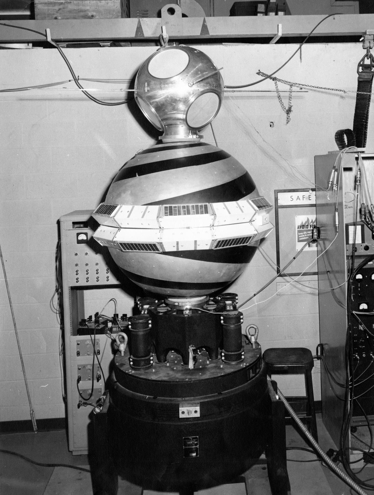
Figure 11.1. GRAB I mounted above the Transit IIA navigation satellite, 1960. Intelligence collection and satellite navigation were literally stacked together in this early space-era hardware, a striking precursor to the positioning infrastructure now taken for granted. National Reconnaissance Office / U.S. Naval Research Laboratory. Public domain.
On 19 August 1960, somewhere over the Pacific, an aircraft crew was waiting for a small object to fall out of space.
The object descended beneath a parachute. Captain Harold Mitchell and the crew of a modified C-119 had been sent to catch it in mid-air with a hook and winch. They missed twice. On the third pass, the aircraft snagged the parachute and hauled the capsule aboard. Inside was exposed photographic film that had orbited the Earth.
The mission had launched the previous day under the public name Discoverer XIV. Its real purpose belonged to CORONA, a secret American reconnaissance programme. The satellite photographed Soviet territory, ejected a film capsule and returned the physical roll through the atmosphere. The successful mission brought back roughly 3,000 feet of film covering about 1.65 million square miles of Soviet territory, more Soviet photographic coverage than all earlier U-2 missions combined, according to the National Reconnaissance Office.[1]
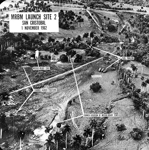
Figure 11.2. U-2 reconnaissance photograph of MRBM Field Launch Site No. 1 at San Cristobal, Cuba, 14 October 1962. Overhead imagery had become evidence at the centre of geopolitical decision-making. U.S. Department of Defense; John F. Kennedy Library; National Archives and Records Administration. Public domain, free of known copyright restrictions.
The recovery method now feels wonderfully mechanical. No digital camera streamed pixels to a server.[2] The United States had to catch the photograph.
What mattered was the new vantage point. A government could gather geographic information about places its aircraft and surveyors could not safely enter. The old story of map knowledge had moved into orbit.
CORONA grew from Cold War intelligence needs, especially after a Soviet missile brought down Francis Gary Powers’s U-2 on 1 May 1960 and President Dwight Eisenhower stopped such overflights of the Soviet Union. The satellite programme continued until 1972 and eventually produced hundreds of thousands of images. Later, after declassification, photography collected for intelligence became useful for environmental research, archaeology and historical analysis.
CORONA is the opening rather than the main story. Reconnaissance satellites answered one question: what is down there? A second satellite revolution answered another: where am I?
That revolution began almost as soon as the space age itself. In October 1957, the Soviet Union launched Sputnik. At the Johns Hopkins University Applied Physics Laboratory, William Guier and George Weiffenbach listened to its radio signal and realised that Doppler shift could reveal the satellite’s motion. As Sputnik approached, the received frequency changed; as it receded, the shift reversed. Their colleague Frank McClure recognised that the logic could be turned around. If the satellite’s orbit were already known, a receiver on Earth could use the signal to determine its own position.
The idea became Transit, the United States Navy’s satellite navigation system. A small constellation of low-orbit satellites broadcast predictable signals. Ships and submarines measured the Doppler shift and calculated a position when a suitable satellite passed overhead. The system was especially valuable for updating the inertial navigation of Polaris submarines. It eventually became useful well beyond the military, including merchant shipping, surveying and science, and was released for broad international use in 1967.
Transit was satellite navigation by appointment. A user could wait for a pass, take a fix and then continue. It was a remarkable improvement, but not yet the continuous blue dot.
During the late 1960s and early 1970s, different American military programmes explored more continuous forms of satellite navigation and precise timing. In 1973 these strands were brought together in the programme that became NAVSTAR GPS. The first developmental GPS satellites were launched in 1978.


The basic geometry can be explained without a page of equations. A GPS satellite broadcasts a message containing the time the signal was sent and information about its orbit. A receiver compares that time with the time of arrival. Because radio signals travel at the speed of light, the difference provides a measure of distance. One satellite gives a large set of possible positions. Several satellites narrow the possibilities until the receiver can solve for its position and its own clock error.
The system is a technological descendant of Harrison’s longitude watch. Harrison carried accurate reference time aboard the ship. GPS put extraordinarily stable clocks in orbit and made the comparison electronic and continuous.
For much of its development, GPS remained military infrastructure.[3] The policy decision that pushed it toward a genuinely global civilian role followed a catastrophe.
On 1 September 1983, Korean Air Lines Flight 007 deviated far from its intended route between Anchorage and Seoul and entered Soviet airspace. A Soviet fighter shot the Boeing 747 down near Sakhalin Island. All 269 people aboard were killed. The precise chain of navigation and human failures remained the subject of investigation and controversy, but the disaster made the value of reliable civilian global positioning impossible to ignore.
On 16 September, the Reagan administration announced that the United States would make GPS available to civilian aircraft once the system became operational. GPS had not been invented because of Flight 007.[4] The disaster accelerated and formalised the policy decision to open a military positioning system for civilian use.
That decision produced unusual infrastructure. The satellites remained owned and operated by the United States military, but civilian receivers around the world could use the signal. A fishing boat in the Pacific, a surveyor in New Zealand and eventually a phone in someone’s pocket could listen to the same constellation.
Civil access did not initially mean full performance. During the 1990s, the United States deliberately degraded the standard civilian service through Selective Availability. Positions wandered more than the underlying system required. Civil users responded with differential techniques and other corrections that recovered much of the lost accuracy for applications prepared to do the extra work.
Then, shortly after midnight on 2 May 2000 in the eastern United States, the artificial wandering collapsed. President Bill Clinton had ordered Selective Availability switched off.[5] GPS.gov records civilian accuracy improving by roughly an order of magnitude. Receivers around the world became much more useful without their owners replacing the hardware.
A policy setting in a satellite system changed while coastlines and survey marks stayed where they were, and civilian positioning became markedly more precise overnight.
The timing was ideal. Receivers were becoming smaller, cheaper and less power-hungry. Satellite positioning moved through car navigation, surveying, agriculture and specialist handheld devices into mobile phones. By the late 2000s, location was becoming a background capability of a device people carried for many reasons other than navigation.
That difference changed the cultural position of maps. A handheld GPS receiver announced that the user was doing a geographic task. A smartphone could invoke location while the person ordered food, found a bus, recorded a run, booked a ride, tagged a photograph or searched for a nearby shop. Positioning became an invisible service.
The blue dot is the visible symbol of that transition. A printed map usually required the reader to determine their own position from signs, landmarks, bearings or prior knowledge. A phone can place the reader on the map automatically and continually recalculate the map around them.
The dot is not produced by the map projection.[6] Satellite navigation provides position and time within a reference framework. The basemap, projection, road data, routing engine and application then use that position for other jobs. Those layers cooperate so smoothly that the user experiences them as one map.
The important change was social and infrastructural: precise global positioning escaped the specialist instrument, while the coordinate-system metadata beneath it remained largely invisible.
There is also a political history beneath the convenience. GPS is not a natural feature of the atmosphere. It arose from decades of American military research, spending and policy. Other global navigation satellite systems now provide alternatives and complements, including Europe’s Galileo, Russia’s GLONASS and China’s BeiDou. Modern devices often combine several constellations, which is why specialists increasingly speak of GNSS rather than treating GPS as the whole category.
The signals are not infallible. They can be blocked, jammed or spoofed. Buildings, terrain and atmosphere affect reception. Accuracy depends on receiver quality, available satellites, corrections and method. A number displayed to six decimal places still does not guarantee six-decimal-place truth.
Even with those limitations, the historical change is extraordinary. In 1960, the United States needed an aircraft over the Pacific to catch film returning from space. Early satellite navigation users could wait for a suitable pass. Four decades later, ordinary civilian receivers could determine position continuously to within metres, and soon the receiver disappeared inside the phone.
A technology built around submarines, missiles, reconnaissance and Cold War uncertainty became part of the ordinary geography of daily life.
That transformation also changed the volume of geographic data people could create. A navigator once wrote a fix in a logbook. A modern device can generate a continuous track. Photographs acquire coordinates. Vehicles generate histories. Wildlife collars transmit movement. Scientific instruments time-stamp observations against a common global reference. The user is not merely reading geography. Their device can continuously produce it.
The map on the phone hides this complexity extremely well. Open an unfamiliar street in Auckland or Seoul and a marker appears. The user does not need a chronometer, sextant, triangulation station or paper chart. They may not know which satellites the receiver heard.
The ease is real, as are the invisible standards underneath it. A satellite may know where the receiver is and the data can still appear in the wrong place if the computer has been given numbers without the rules that explain what those numbers mean.