CHAPTER 10
FINDING YOURSELF ON EARTH
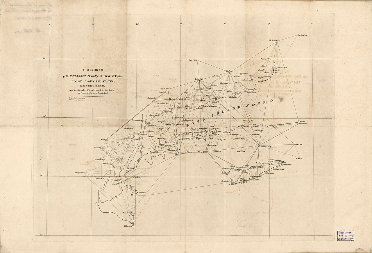
Figure 10.1. U.S. Coast Survey triangulation diagram, 1834. Position is built from networks of measured relationships: triangles spreading across the landscape until local measurements become a geographic reference framework. U.S. Coast Survey / Library of Congress, Geography and Map Division. Public domain.
In November 1761, a ship called the Deptford left Portsmouth for Jamaica carrying a watch.
Not an ordinary watch. John Harrison’s H4 marine timekeeper had been completed after decades of work on clocks designed to keep reliable reference time while a ship pitched, rolled, heated, cooled and crossed an ocean. Harrison’s son William carried H4 on the voyage as part of its formal trial.[1]
During the voyage, William Harrison used the timekeeper to predict that Madeira would appear sooner than the crew expected. He was right. The episode is usually told as a triumph of clockmaking, but the watch mattered because it answered a geographic question: where are we?
Latitude, the north-south part of the answer, had long been comparatively manageable at sea through observations of the Sun and stars. Longitude was harder. To know how far east or west a ship had travelled, the navigator needed local time and the time at an agreed reference meridian. The Earth rotates 360 degrees in about twenty-four hours, so one hour corresponds to fifteen degrees of longitude.[2] The arithmetic is easy. The hard part was carrying reference time accurately across the ocean.
A clock error became a position error. H4 did not make longitude effortless or instantly replace astronomical methods. Lunar distances developed alongside marine chronometers, accurate instruments remained expensive, and Harrison’s dealings with the Board of Longitude became famously contentious. The larger change was nevertheless profound. A navigator could increasingly carry a stable reference with the ship. Position became easier to measure consistently rather than reconstruct only from dead reckoning and occasional astronomical fixes.
The same principle becomes more demanding on land when the required precision shrinks from kilometres to metres or centimetres. A coordinate looks like a property of a place, but it is really a description inside a reference system.
A survey mark makes the distinction physical. Imagine a brass disk set into concrete on a hill. The mark can be touched. An instrument can be placed above it. The coordinates assigned to that mark, however, depend on the geodetic framework being used. Change the datum and the brass disk does not move, yet the coordinate values can change.
The word datum often appears in software as an obstacle between the user and the map. The underlying idea is simpler. A geodetic datum provides the reference framework that connects coordinate numbers to the real Earth. It uses a defined coordinate system and a smooth mathematical model of the Earth, generally an ellipsoid. Modern systems may also include rules for movement over time.
The ellipsoid exists because the Earth is not a perfect sphere. It is slightly flattened at the poles, wider around the equator and irregular in ways that are awkward for calculation. Geodesists do not use an ellipsoid because they believe mountains and ocean trenches are imaginary. They use it because a precise mathematical surface makes a national or global coordinate system possible.
For much of surveying history, countries built their own reference frameworks from observations made on the ground. Surveyors measured baselines, observed angles and extended networks of triangles across landscapes. Triangulation is one of the great technologies hidden by simple geometry. Measure one distance exceptionally well, observe enough angles, and a connected network can spread position across a country without every distance being measured directly.
New Zealand’s survey history shows why a national framework matters. European settlement and cadastral work did not wait for one complete geodetic network. Local and regional surveys grew first. As larger and more accurate triangulation networks developed, older work sometimes had to be reconciled with the newer framework.
High ground acquired trig stations because one survey point needed to see another. A trig was not there to improve the view; it was part of a national geometry. The first-order national triangulation is generally dated from measurement of the Wairarapa Baseline in 1909. The network took decades to complete. In 1949 New Zealand adopted NZGD1949, a national geodetic datum based on astronomical observations, triangulation and the International 1924 ellipsoid.[3] Survey marks across much of the country could now be related to one national framework rather than a collection of regional systems.
That was an enormous practical achievement. A road project in Waikato, a boundary survey in Canterbury and topographic work in Otago could all refer to a common national geometry. The system gave surveyors a shared mathematical answer to where their control points were.
The answer was designed for the technology of its time. NZGD1949 was static. Once the defining coordinates were established, they did not continuously change. Over later decades, the limitations became more apparent. LINZ records regional distortions of up to about five metres, along with uneven densification, limited offshore coverage and increasing incompatibility with satellite-based positioning.[4]
Five metres is trivial on a world map, but not at a property corner or engineering site. The arrival of satellite geodesy exposed another assumption. Global satellite systems work most naturally with Earth-centred reference frames. New Zealand, meanwhile, sits across the boundary between the Australian and Pacific tectonic plates. The land itself moves relative to those global frames.
NZGD2000 was created for that world. Officially adopted in 1998, the New Zealand Geodetic Datum 2000 is aligned to an international terrestrial reference frame at a reference epoch of 2000.0 and uses the GRS80 ellipsoid.[5] The epoch is the conventional date at which the datum’s coordinates are defined, not its adoption date. More unusually, NZGD2000 is semi-dynamic.
The phrase contains one of the stranger truths in modern mapping: New Zealand is moving. Relative to a global Earth-centred frame, points in New Zealand can move by around five centimetres a year as the tectonic plates move and deform.[6] Over twenty-five years, five centimetres a year accumulates to about 1.25 metres. LINZ has used that order of magnitude to explain why time-dependent transformations matter when relating NZGD2000 to dynamic global reference frames.
A fully dynamic coordinate can therefore change with time even if the survey mark remains attached to the same piece of ground. For a national cadastre or engineering system, allowing every familiar coordinate to drift a little each year would be inconvenient. NZGD2000 instead uses a deformation model so current observations can be related back to the datum’s reference epoch. The model absorbs ordinary plate motion in a controlled way, giving users stable national coordinates while preserving a rigorous path to global frames.
Time has become part of position, which sounds abstract until the ground moves suddenly.
At 12.02 a.m. on 14 November 2016, the magnitude 7.8 Kaikōura earthquake ruptured a complex sequence of faults across the north-east South Island. Large parts of central New Zealand shifted. Survey marks moved with the land. Coordinates that had described the pre-earthquake geometry accurately enough for high-precision work no longer represented the post-earthquake ground in the same way.
This was not a database mistake. The country had moved, and geodesists responded with new observations and revisions to the national deformation model. In January 2018, LINZ released an updated NZGD2000 deformation model incorporating movement caused by the Kaikōura earthquake and subsequent deformation. In the most affected areas, resulting horizontal coordinate changes reached as much as about six metres, though most locations changed by much less.[7]
The distinction here is important. The earthquake caused physical ground displacement. Later model revisions changed the coordinates used to represent that altered geometry consistently. Those are related events, not identical ones.
After major earthquakes, precise positioning can therefore need more than latitude, longitude and height. Surveyors may need to record the datum, its version, the coordinate epoch and the observation source. The question “where?” becomes “where, relative to which framework, and when?”
A coordinate is not a permanent label nailed to the Earth. It is a position expressed inside a defined reference system. The better the measurement becomes, the more the reference matters.
Harrison’s watch carried reference time across an ocean. Triangulation spread a reference network across a country. NZGD1949 gave New Zealand one national geodetic framework. Satellite geodesy made Earth-centred positioning ordinary. NZGD2000 added time and deformation because the New Zealand landmass would not remain still for the convenience of the coordinates.
The machinery is mostly invisible to ordinary map users, which is a sign that it works. A person opens a phone and sees a blue dot. They do not see the ellipsoid, reference epoch or deformation model beneath it.
The longitude problem began with carrying a clock across the ocean. By the twentieth century, reference time and position would be broadcast from machines moving through space.