CHAPTER 7
MAPS WORTH STEALING
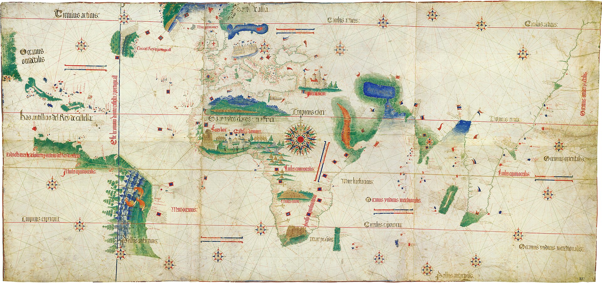
Figure 7.1. The Cantino Planisphere, 1502. Made by an anonymous Portuguese cartographer. This celebrated world map was covertly copied in Portugal for Alberto Cantino, making it an unusually literal example of geographic information worth stealing. Biblioteca Estense Universitaria, Modena. Public domain.
In 1502, Alberto Cantino had a problem familiar to intelligence officers in every century: the information he wanted belonged to somebody else.[1]
Cantino was in Lisbon working for Ercole I d’Este, Duke of Ferrara. Portugal was accumulating some of the most commercially valuable geographic knowledge in Europe. Portuguese voyages had rounded Africa, reached India by sea, crossed the Atlantic to Brazil and pushed into waters that remained uncertain on many European maps. Routes, ports, coastlines and discoveries were not merely interesting. They were advantages.
A coastline could be a commercial secret. A sailing route could be a state asset. A world map could be worth stealing.
The document that came to bear Cantino’s name is now known as the Cantino Planisphere. The surviving original, held in Modena, is more than two metres across and drawn richly on parchment. It shows Europe and Africa, the Atlantic, recently charted parts of the Americas, the route around the Cape of Good Hope toward India, and geographic information that had reached Lisbon only recently from Portuguese voyages.
The precise circumstances of its creation require caution. Institutional accounts describe Cantino as an Italian agent who is believed to have bribed a Portuguese cartographer for a copy and sent it clandestinely to Ferrara. Modern scholarship is more careful about treating the surviving map as a simple copy of one perfectly controlled royal master chart. The larger point is much firmer: Cantino obtained privileged Portuguese geographic information for another court, and that information was valuable because it was difficult to acquire.[2]
Today a world map is among the least secret objects imaginable. A child can inspect coastlines, roads, ports and satellite imagery on a phone. In Lisbon in 1502, detailed knowledge of a recently explored coast could be the product of an expensive and dangerous voyage, collected by pilots and navigators, paid for by a crown and guarded because another state could use the same knowledge for trade and power.
Cartography was part of intelligence because a map could do something a pile of reports could not. It assembled information spatially.
A letter might say that Portuguese ships had reached India. A map could show the route around Africa. A report might describe a new coast. A map could place it relative to islands, ports and the line agreed at Tordesillas. Facts became relationships.
That is the peculiar value of geographic intelligence. A warehouse is information. A warehouse beside a navigable river, connected to a road and close to a bridge with a known load limit, is a different kind of information. Location turns isolated facts into a system.
The expensive part of a map is often not drawing it. The expensive part is knowing enough to draw it.
For early navigators that knowledge came from voyages, observations, dead reckoning, soundings, local knowledge, coastal sketches and accumulated experience. For later survey departments it came from field crews and instruments. For intelligence agencies it could require aircraft, satellites, analysts and spies. The map is the compression format.
Cantino’s map also had an extraordinary afterlife. Commissioned for Ercole I d’Este, the planisphere ultimately entered the collections now held by the Biblioteca Estense Universitaria in Modena, where it survives as one of the library’s celebrated cartographic treasures. Later accounts disagree over some details of its nineteenth-century rediscovery, so the safer irony is simpler: information acquired for strategic advantage can outlive the political purpose that made it valuable.[3]
A map’s value is not permanently stored in the parchment. It depends on who knows what the sheet contains and what can be done with the knowledge.
Four and a half centuries after Cantino, another government attempted a geographic intelligence project at an astonishing scale. During the Cold War, the Soviet Union produced topographic maps covering enormous areas outside Soviet territory and detailed plans of more than two thousand foreign towns and cities. Many city plans were made at scales such as 1:10,000 or 1:25,000 and marked СЕКРЕТНО: secret.
One of them was Dover, at the narrowest part of the English Channel, facing continental Europe. Harbour, railways, cliffs, tunnels, military history and transport infrastructure occupy a compressed strategic geography. A Soviet military plan compiled in 1972 and printed in Saratov in February 1974 mapped the town at 1:10,000, listed twenty-nine strategically important objects and included a descriptive text of around a thousand words.[4]
Some of the detail is unsettlingly practical. The plan recorded transport and industrial facilities, showed the railway tunnel beneath Shakespeare Cliff, marked ventilation shafts, included harbour depths and soundings, and identified military, government, communications and industrial sites with a standardised system of numbers and colours.
It also made mistakes. A coal-handling aerial ropeway dismantled decades earlier survived on the Soviet plan. One industrial site appears to have been misclassified, perhaps because information had been inherited from an older German wartime source. Important underground facilities were absent.
The errors make the map more revealing. An intelligence map is not a magical view from nowhere. It is an argument assembled from sources. Some information is current, some old, some copied, some inferred and some wrong. The finished sheet can look far more certain than the process that produced it.[5]
Researchers comparing the Dover plan with British mapping have found evidence that Soviet cartographers were not simply tracing one Ordnance Survey source. Terrain, hydrography and strategic information were combined and reorganised for military purposes. Existing maps were inputs, not the final product.
This links Cold War Dover to Renaissance Lisbon. In both cases, the valuable thing is the combination. Geographic information gains power when separate observations share location and can be read together.
A modern GIS analyst recognises the logic immediately. Roads, bridges, slope, vegetation, ports and fuel depots can each exist as separate datasets created for ordinary civilian purposes. Combine them and a new question becomes possible, one none of the original publishers needed to ask. The map becomes more than the sum of its layers.
This is also why geographic secrecy is difficult. A government can classify a report more easily than it can conceal a coastline. A bridge plan may be restricted while the bridge itself remains visible to travellers, photographers, planning records, shipping notices and sensors. The information needed for a map can leak through people, publications, commercial charts, engineers and observations made from somewhere else.
States still try. The Portuguese crown attempted to control sensitive charts. Twentieth-century militaries classified detailed mapping. Governments today continue to restrict some geospatial information and high-resolution imagery. The incentive is durable because where something is can still be valuable knowledge, especially when the other side does not know what you know about it.
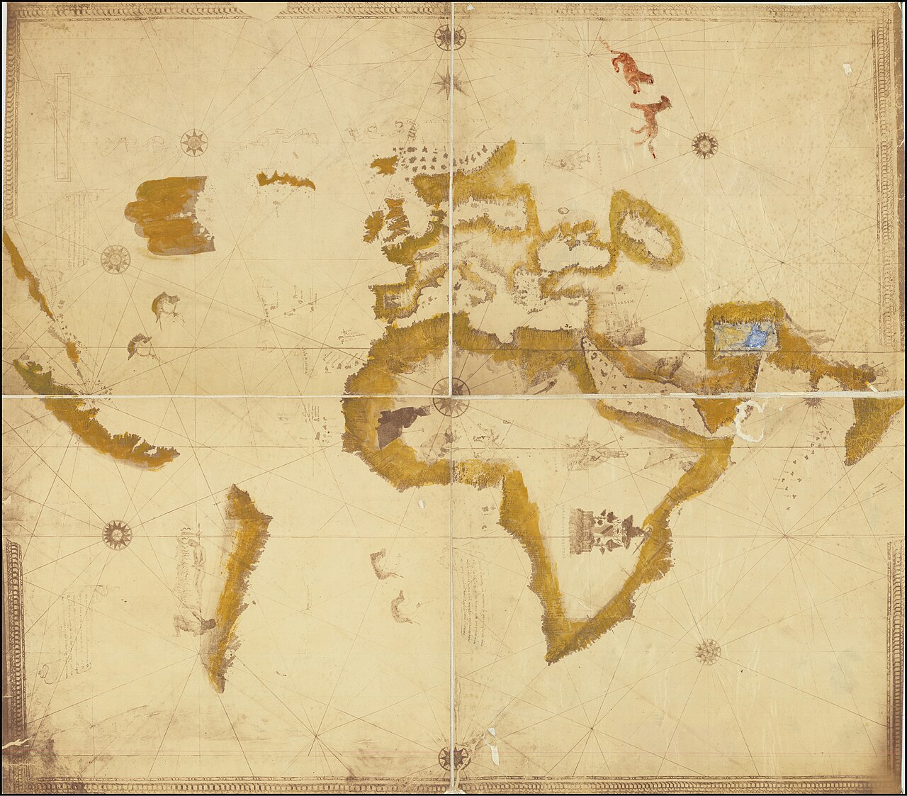
Figure 7.2. Kunstmann II portolan chart, c.1502–1506. Anonymous, attributed to Amerigo Vespucci. Charts like this condensed newly valuable coastlines, routes and geographic intelligence into portable objects, helping explain why states tried to control cartographic knowledge. Wikimedia Commons reproduction of a public-domain work. Public domain.
The Soviet maps eventually escaped too. After the collapse of the Soviet Union, sheets that had been secret began appearing commercially. In the 1990s, Western cartographers and collectors could buy maps that had once been created to support Soviet military planning.[6]
A classified plan could become a research object, and the political system that produced it could disappear while the geographic information survived. The pattern recurs throughout cartographic history. Military surveys become civilian basemaps. Intelligence imagery becomes environmental or archaeological evidence. Colonial surveys become sources for Treaty research. A map’s second life may have almost nothing to do with the task that first justified its creation.
Cantino’s plan now reveals the geographic knowledge Portugal possessed and another court’s appetite to acquire it. The Dover plan reveals what Soviet military cartographers considered worth knowing about an English port and how successfully they could reconstruct it from afar.
Neither was created mainly to persuade a public audience. They were working instruments intended to support advantage. Propaganda maps try to influence what viewers feel or believe; intelligence maps often exist to help somebody act by navigating, trading, landing, moving troops, assessing terrain or choosing a route.
Operational usefulness can make the important parts of a map look almost boring. A bridge’s load capacity may matter more than a dramatic national boundary. Harbour depth may matter more than an elegant coastline. War and logistics happen through details.
Maps are often most powerful when they stop being pictures of territory and become instructions for acting inside it.
There is a further caution. Secret cartography should not be told only as a story of clever state mapmakers and spies. Official maps have often depended on guides, pilots, interpreters and local communities whose knowledge disappeared beneath the names of institutions or surveyors. A place may be secret in a government archive while being thoroughly known to the people who live there. Secrecy is a relationship around recorded knowledge, not a property of the landscape itself.
A reef is not classified. A government’s precise assessment of it might be. A city is visible to its residents. A compiled database of every road width, tunnel, depot and communications site is something else.
Cantino had to get a physical map out of Portugal. A modern dataset can be copied perfectly and cross the world without leaving the original owner with one fewer copy. The better geographic information becomes at travelling, the harder it becomes to contain.
The map Cantino obtained in Lisbon survived the empire that tried to guard the information behind it. The Soviet plan of Dover survived the Soviet Union. What began as advantage became archive.
Once geographic information is standardised, gridded and distributed through an army, it can become operational at the scale of metres.