CHAPTER 6
SURVEY AFTER CONQUEST
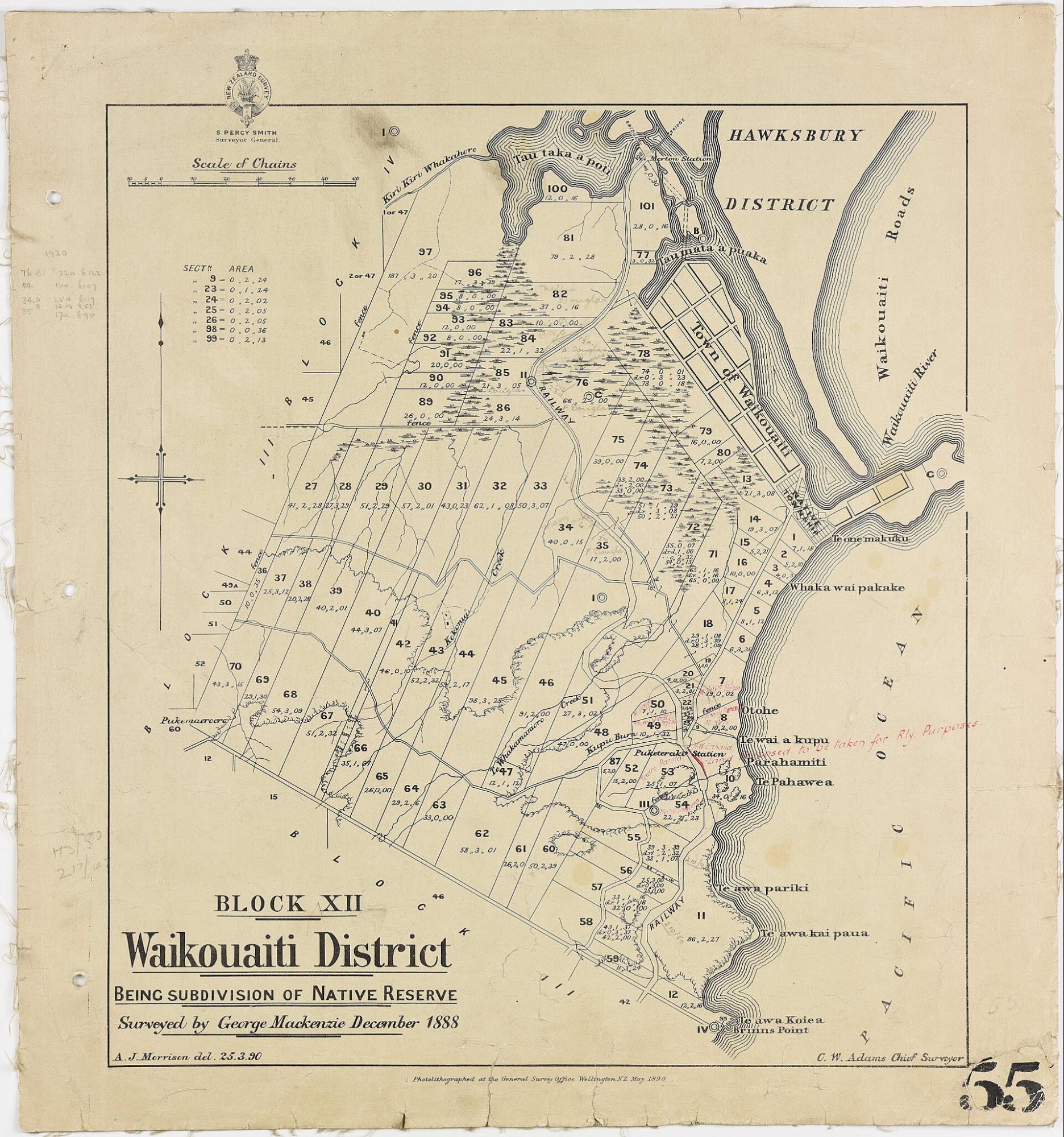
Figure 6.1. Subdivision of a Native Reserve in Block XII, Waikouaiti Survey District, 1888. The survey map turns land into measured parcels, boundaries and numbered sections. New Zealand Railways Corporation, District Engineer's Office, Dunedin / Archives New Zealand, DABB D101 409/55 - R6619117. CC BY 2.0.
A survey peg is a very small object to carry so much argument.
In 1879, government surveyors were working across confiscated land on the Waimate Plain in south Taranaki. Their task was ordinary by the standards of a colonial administration: measure the land, mark boundaries, lay out roads and sections, and prepare the ground for settlement.
The work required an abstract scheme to become physical. A line in a plan or instruction had to touch the land somewhere. Survey pegs did that quietly, one point at a time.
The people of Parihaka understood what those pegs meant. Under the leadership of Tohu Kākahi and Te Whiti-o-Rongomai, Māori resisting the settlement of confiscated land disrupted the surveys, removed pegs, ploughed land occupied by settlers and built fences across roads cut through their cultivations. The resistance was deliberately non-violent, but it attacked government policy at the moment that policy was becoming recoverable geography.
A surveyor could replace a peg; the argument was about the authority behind it. That is one of the most useful things to understand about surveying. Measurement can be technically exact while the arrangement being measured remains politically contested. The angle, distance and traverse can all be correct. None of those observations decides who was entitled to order the survey. Once an institution has made that prior decision, however, surveying can make the decision durable.
Cadastral surveying does more than measure. It translates land into legal parcels that can be identified, recorded, sold, taxed, mortgaged, inherited, subdivided and disputed. In New Zealand, cadastral survey plans extend back into the nineteenth century and remain part of the infrastructure beneath property records. A modern title can feel like an obvious description of a patch of Earth, but a parcel is a legal and spatial object that had to be defined.
That distinction was especially consequential in a colonising society. Māori had long-established systems of land tenure, territory and resource rights, with relationships grounded in whakapapa, occupation, cultivation, fisheries, forests, seasonal use and connections among whānau and hapū. Rights could overlap. The colonial state did not encounter an absence of land relationships. It sought to translate them into a system that its own courts, titles and land market could administer.
Law did part of that work and surveying did another. The Native Land Court became central to the transformation. In its nineteenth-century operation it converted customary interests into titles recognised by colonial law.[1] Before the court could investigate a block, land generally had to be surveyed, and owners were expected to meet the costs. A survey plan therefore did not merely illustrate the court’s decision after the fact. It helped turn the land into an object that the court could identify and process.
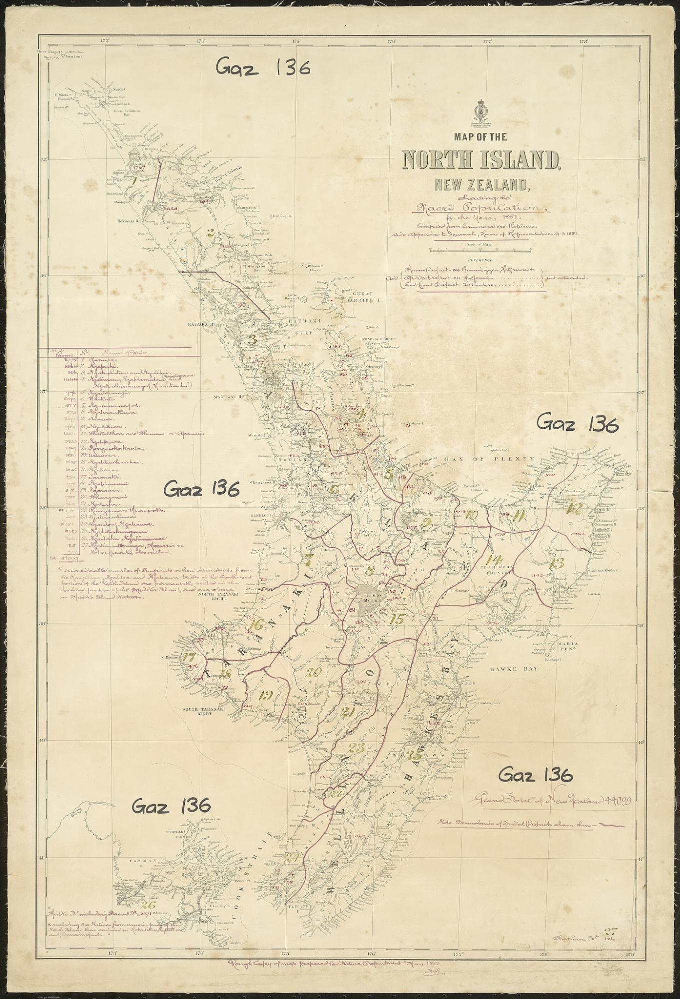
Figure 6.2. North Island map showing iwi boundaries and Māori population, 1881. This is a colonial-state cartographic classification, not an authoritative statement of iwi geography. It is useful here because it shows how Indigenous land and people were translated into administrative map categories. Archives New Zealand. CC BY-SA 2.0.
A place may be completely intelligible to the community that lives there through names, whakapapa, use, memory and relationships. A bureaucracy operating at distance wants something different: an object with a defined extent, an area, recognised owners and a record that can be found again. Surveying helps create that administrative legibility.
An earlier Wellington episode makes the politics of the peg unusually clear. In 1840, when surveyors marked out the colonial town at Te Aro, Māori pulled up pegs because they disputed that the land had been sold.[2] Nearly four decades later, the same physical action appeared at Parihaka. The legal systems and circumstances were different, but the peg still marked the point where an external decision entered the ground.
By the 1870s, New Zealand’s surveying system was itself becoming more organised. Early colonial surveys had been fragmented among provinces and practitioners of uneven quality. Expanding settlement and land transactions exposed overlapping boundaries, inconsistent records and surveys that could not be reconciled cleanly. In 1876 the provincial survey systems were brought into a national structure under a Surveyor-General, with professional regulation tightening over subsequent decades.[3]
This administrative story lacks the drama of Parihaka but explains why cadastral systems become so powerful in ordinary life. A land market needs confidence that the parcel sold this year can be found by another surveyor decades later. A mortgage needs a legally identifiable property. A road reserve needs recoverable edges. A town needs sections. The stronger the survey framework, the easier it becomes for institutions to act consistently on land records.
For Māori owners passing through the Native Land Court, the costs of this system could themselves become a mechanism of loss. Surveying had to be paid for. Te Ara notes cases where survey costs consumed twenty per cent or more of a block’s value, alongside court, travel and other expenses.[4] Waitangi Tribunal research records instances in which land was surrendered to meet survey charges and reports nearly 40,000 acres associated with Ngāti Maniapoto survey costs, while also showing why such figures must be handled carefully by district and evidence.[5][6]
The mechanism is more important than one national total. A community could need a survey for title recognition under the colonial system. The survey created a debt. That debt could then contribute to land being sold or surrendered. The process that made ownership legible to the state could therefore help place ownership under financial pressure.
Surveying is also indispensable to modern Māori land administration, Treaty settlement work, infrastructure, environmental management, housing and the protection of legal rights. Precision is useful. Its political meaning depends on the institutional decision that precision is being used to implement.[7]
At Parihaka, the answer was inseparable from confiscation and settlement. The government had confiscated large areas of Taranaki land during and after the wars of the 1860s. Promised reserves remained unresolved.[8] Survey work on the Waimate Plain accelerated in 1878 and 1879, and Te Whiti and Tohu’s followers resisted the process through peg removal, ploughing and fencing.[9] The government responded with arrests. On 5 November 1881, a force of roughly 1,600 volunteers and Armed Constabulary entered Parihaka.[10] Te Whiti and Tohu were arrested, and the settlement was broken up.
The story is properly remembered as one of non-violent resistance and state violence. It is also a story about what happens after territory has been claimed. Conflict can move from armies into surveys, roads, reserves, titles and settlement. Surveying helps organise what happens next.
That administrative afterlife is visible in the records. A nineteenth-century peg may disappear while the line associated with it survives through survey plans, titles, coordinates and later resurvey. The physical marker can be temporary. The administrative geometry can last for generations.
This is why cadastral records are such rich historical documents. They can preserve old place names, occupation lines, fences, streams, road proposals, reserves and the work of surveyors who could not have imagined a digital cadastre. They show land at the moment it is being fitted into a system of sections, blocks, lots, roads, reserves and titles.
Those categories are ordinary parts of a modern land system. They are also historical products. Once a parcel has a legally recognised boundary and record, it can enter institutions that depend on those things. It can be transferred, mortgaged, rated, partitioned, inherited or subdivided. The map does not perform those acts by itself. It gives the institutions a stable object on which to act.
A cadastral plan can therefore be more consequential to a person than a famous world map. The world map asks how the planet should be represented. The cadastral survey asks where this piece of land ends, and who the legal system recognises on either side.
At Parihaka, pulling out the pegs did not erase confiscation law or defeat the government. It revealed the machinery required to turn the state’s decision into sections, roads and settler titles. Those outcomes did not emerge automatically from conquest. They had to be measured and recorded.
Precision also made geographic knowledge valuable. Detailed geographic knowledge could support administration, property and infrastructure, but it could also become an advantage worth guarding or stealing.